

-
- About Us
-
Our Services
Downloads
Training & Suggestions
Inspection
-
Other Offices
Division / District
Ministry/Division & Department
- e-Services
- Gallery
- Opinion
-
- About Us
-
Our Services
Downloads
Training & Suggestions
Inspection
-
Other Offices
Division / District
Ministry/Division & Department
- e-Services
- Gallery
- Opinion
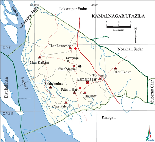
Area: 315 sq km
Location: 25 km south of Laxmipur district headquarters.
It is bounded by ramgati upazila on the south, laxmipur sadar on the north, noakhali sadar on the east, meghna river on the west, noakhali sadar upazila on the east.
Population: 2,22,915.
Constituency - Laxmipur-4 (Ramgati-Kamalnagar)
Union 09, Union Land Office 05, Post Office 06, Hatbazar 25, Bank 14
Ramgati Upazila on the south, Laxmipur Sadar on the north, Noakhali Sadar on the east, Meghna River on the west, Noakhali Sadar Upazila on the east.
On November 18, 2005, the 93rd meeting of the National Committee for Administrative Restructuring approved the proposal to divide the Ramgati Upazila of Laxmipur District and form the 462nd Upazila of the country named "Kamalnagar". The upazila was officially inaugurated on 20 September 2006.
1. Char Kalkini UP 2. Saheberhat UP 3. Char Lorench UP4. Char Martin UP5. Char Falcon UP 7. Patarirhat UP 6. Hazirhat UP 6. Char Kadira UP 9. Torabganj UP
Tradition of the upazila
Meghna hilsa, soybean, buffalo curd


Visitor Number
Planning and Implementation: Cabinet Division, A2I, BCC, DoICT and BASIS
Technical Assistance:
![]()
Developed By:
